Henge Monument LayoutAlong with the Mesolithic Hut that I showed you in my previous post the Maelmin Heritage Trail also displays a reconstructed henge monument and a Dark Age house.

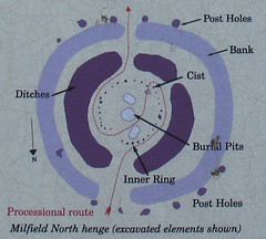
In the first picture you can see where the henge is in relation to the Mesolithic hut.  The henge is based on the ground plan of the Milfield North henge.  The Milfield North henge was excavated during the 1970’s and with the use of radiocarbon dating found to have been built around 2300BC.

The centre of the henge contained three pits. The middle one contained a pot which was a food vessel and another object which was possibly a wooden coffin for burial. The other two pits were thought to be grave pits although due to the acidity of the soil no bones or skeletons remain.

The reconstruction of the henge represents one of the possible ways that it might have looked.  The hurdles and inner ring posts may have been placed differently.

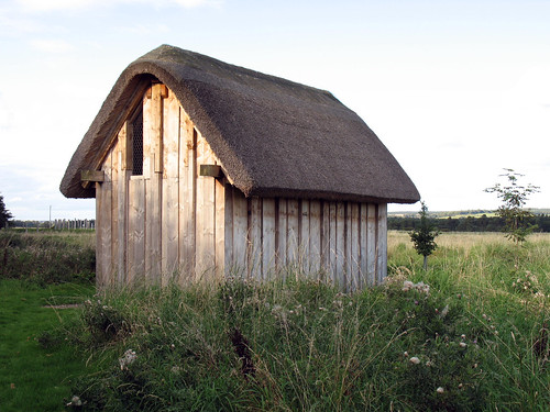
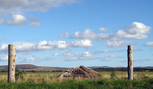
The Dark Age house is a full-scale reconstruction of one of three such buildings that were excavated at Tarmac’s Cheviot Quarry.  The original buildings are dated between AD 410-550.

“It measured 7 metres long by 3.25 metres wide, with seven pairs of opposed post which averaged 0.2 metres across.  The excavations revealed that the posts were set vertically, which implies the roof was not based on crook beam construction, but instead was likely to have cross beams and pitched roofing timbers as in the reconstruction.  The ideal angle for shedding water on a thatched roof is 50 to 60 degrees, which determined the length of the roof rafters and the height of the roof beam in the reconstruction.  The reconstruction stands at 4 meters at its highest point.

All the joints were made with mortises and tenons, and these were further supported by wooden pegs drilled through the timbers.  The floor rests on timber beams running the length of the house connecting the bases of the wall posts to provide the floor-boards with support.  A similar series of beams, known as a wall plate, connect the vertical wall timbers at the top and bottom and take the weight of the roof.

The choice of overlapping planks for the walls is based on the evidence from houses of a similar age or slightly later elsewhere in England, but the walls might also have been made from wattle and daub (a wooden lattice sealed with a mixture of clay and sand).” *

In the final picture if you look very closely you can just see the henge in the background to the left of the house.
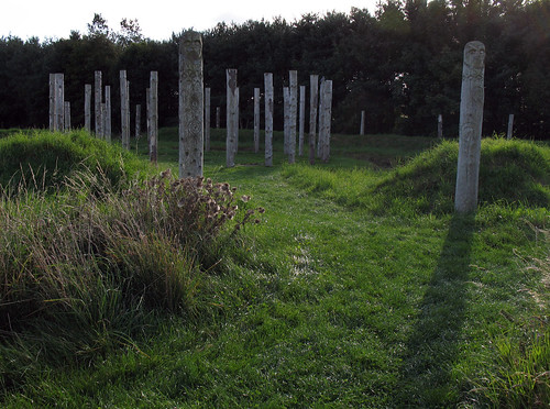
View from the Henge

The Henge Monuments

The Dark Age House

*From an information board at the heritage trail.

6 Comments CherryPie on Oct 25th 2009

photohunt

This Mesolithic hut is part of the Maelmin Heritage Trail at Millfield. The roof has been damaged by the weather, hence the ragged look. As you can see the supports are tied together.

Maelmin was the name of a royal township that existing near the modern day village of Milfield in Anglo-Saxon times. Today it is the site of a series of reconstructions of local archaeological structures.

These enable visitors to experience the scale of the originals which have been lost to time.

a henge, a mesolithic hut and a dark-age house

The reconstructions are faithful interpretations based upon archaeological evidence.

Once there were many henges in the area surrounding Milfield – dating from around 2,000BC. The Mesolithic hut dates from the stone-age and is based on a find at Howick, near Alnwick. The Dark-Age house was found a Tarmac’s Cheviot Quarry which is located next to Maelmin.

In Need of Repair

Mesolithic Hut

Explanitory Detail

Clearer detail from the above information board:

Mesolithic

For more of this weeks PhotoHunt pictures check out tnchick.

22 Comments CherryPie on Oct 23rd 2009

After destroying Norham Castle the Scottish Army moved on to Etal castle which fell easily and was therefore left intact.

The castle was built in the early fourteenth century by Robert Manners, in a strategic position by a ford over the River Till.  As a border stronghold, Etal was vulnerable to attack from Scottish raiders, and in 1341, Robert was granted a licence to fortify his home, adding curtain walls, corner towers and a gatehouse.  In 1513,  Etal was suddenly thrust into the forefront of national events, as it was captured by the Scots during James IV’s attempted invasion of England.  The Scots were subsequently defeated at the Battle of Flodden, and Etal was freed.  The union of the English and Scottish crowns in 1603 ended the castle’s active role in history, and it fell into disrepair.  *

At Etal Castle there is an excellent exhibition that explains the Battle of Flodden. It is well worth a visit.

Gatehouse & Corbels

The Tower House

Enlightenment

*From the Etal Castle guide book.

***Index to my posts on Flodden.***

20 Comments CherryPie on Oct 22nd 2009

The Scottish Army crossed the border into England at Coldstream, where they razed Wark Castle before moving onto Norham.  They laid siege to Norham Castle for 6 days before destroying it and  moving on.

A castle was first built at Norham in the twelfth century by a Bishop of Durham.  The huge bulk of this building stands on a site of great defensive strength overlooking the River Tweed.  It was repeatedly attacked and beseiged during the thirteenth and fourteenth centuries, and was captured by the Scots three times between 1136 and 1322.  In 1513 it was stormed by James IV and largely destroyed.  It was later rebuilt to take into account advances in gunpowder artillery, but had lost its importance as a defensive stronghold by the end of the sixteenth century.  *

The Keep

The Gateway

The Ruins

*From the Norham Castle guide book.

***Index to my posts on Flodden.***

12 Comments CherryPie on Oct 21st 2009

This is the first of what is intended to be a series of posts highlighting the places that were significant to the Battle of Flodden.

Before leaving on their journey to the borders, the Scottish Army assembled just outside Edinburgh.

Quite by fluke I found myself having an in-car picnic near the town of Duns where the Scottish army camped during their journey to Flodden.  I had just bought my sandwiches when,  quite normally  when I am intending a picnic, it started to rain.   At least it gave me a chance to visualise what the conditions must have been like in the run up to the battle, before I was able to escape the rain by crossing the border back to England and sunshine.

The Forest of Duns

***Index to my posts on Flodden.***

13 Comments CherryPie on Oct 20th 2009

For a few weeks now I have been wanting to go to Attingham Park to check out the autumn colours.  Yesterday was the ideal opportunity.  The weather was so lovely and for once I wasn’t already busy doing something else.  It was even warm enough to sit outside in the sun and enjoy coffee and walnut cake for lunch.

Strangely enough not many of the trees were showing their autumn coats.  A good excuse to go again soon maybe?  In amongst the green, I did manage to find a few nice colours.  I hope you like them.

The walk round the estate made a nice change from Saturday when I was out waving flags at a rally in Birmingham.  We were supporting the Pensioners Alliance and campaigning for decent pay, pensions and public services.

Golden Glow

Taking a Stroll

Red Embers

12 Comments CherryPie on Oct 19th 2009

A real friend is one who walks in when the rest of the world walks out.
Walter Winchell

Feeling Lonely

8 Comments CherryPie on Oct 18th 2009

« Newer Posts - Older Posts »